Google Maps adds Biking layer

Google have begun to add an option for bike routes within Google Maps:

JN5_NBSu7Lw

This has already been a feature of OpenStreetMap for quite some time, but it’s nice for Google to catch up. Something Google add which I don’t think is in the OSM data is a kind of ‘quality’, where dedicated (no cars) bike paths are one colour, roads with bike lanes are another colour, and other preferred biking roads have a dotted line. Although I’m a little curious about how they get the kind of information to highlight the dotted line routes, I think this is a great addition to Google Maps for all those who are keen bikers.

Google Maps Mobile, the underestimated Google Buzz client

Having released Google Buzz a few days ago and seen the iPhone and Android interfaces which took the GMail-centric UI and simply ported it across to mobile, I was looking for similar integration with my Nokia E71 (S60) device.

I very quickly realised that there wasn’t a new version of the GMail application, but there was a new version of Google Maps. This new version of Google Maps has integration with Google Buzz in the form of a Layer. Once turned on, this layer puts speech bubbles anywhere Buzz has been made. Add to this the fact that Buzz can be associated with places and businesses, this gives an excellent way to provide tips for people to find when they’re travelling.

I have to wonder, with Jyri Engeström having worked on features within Google Buzz, whether this is trying to, in any way build on the concept of the original Jaiku service (not the newer JaikuEngine-based service), where multiple feeds are taken into a single activity stream with location attached. One of my personal main use-cases of Jaiku was for travelling, so I could find people in the area to go for a drink with, and I have been lucky enough to get to know several people from around Finland because of it.
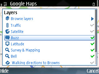
Enable the Buzz layer
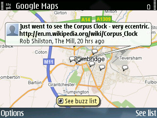
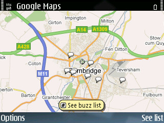
Buzz around Cambridge
A location-specific Buzz

I’ve put some screenshots of how I used it on a night in the pub on Saturday.
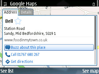
A pub on Google Maps
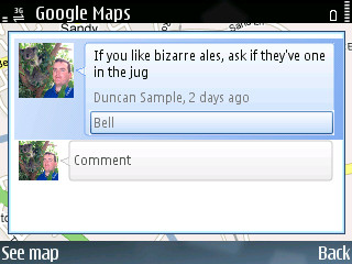
Buzz about the pub

Google Maps Mobile for non-GPS phones

The latest enhancement to Google Maps Mobile allows people that don’t have a GPS enabled phone to get approximate location (within 1km) using mobile operator cell locations.

This is a good enhancement, similar to the Network-based and AGPS feature in new S60-based phones and also the offerings from Navizon. The questionable thing here though is, what cell location data is Google using to estimate this? Nokia and Navizon have started their own databases (Navizon includes both Mobile Cells and WiFi APs)… is Google starting another? What are the chances of standardising and creating an ‘open location database’?

v6gqipmbcok

(brought to my attention through Lifehacker)

Google encourages data corrections

Google have started to allow users to correct their address gazetteer. By searching for your address (I think this is US only for the moment) you will be shown the address marker as normal, but now when you click on the marker you will have the object to edit it and drag the marker to where you think it should be. This sounds to me like free labour on the pretence of better service in the future… a cunning ploy by Google, and one which I will probably join in on when I find a business I’m looking for has it’s marker out of place.

For minor changes it’s an instant fix, but if it’s wildly out (200m or more) the change gets put in a moderation queue.

I’ve been wondering about this kind of thing for a while and it’s nice to see more collaborative mapping happening… now, if we could only convince Google to collaborate on OpenStreetMap.

Google Maps gets collaborative

Google have added a new collaborative feature to My Maps. If you are logged in when using Google Maps you will now see an ‘Edit’ button when viewing user generated maps that you have permissions to modify. This is a great addition to the Google Maps feature line-up and should come in handy when you’re planning that next outing with friends.

(brought to my attention through Lifehacker)

Google Maps gets a native S60v3 version

If you tried the previous Google Mobile Maps application before and have an S60v3 phone, you might want to update to the new native version. It’s got a smoother display and now supports GPS, so all you N95 (or bluetooth GPS) owners can see where you are.

It doesn’t do satnav yet, but it can’t be too long before Google comes up with something to rival the subscription-only navigation of Nokia Maps and Tomtom. The only benefit Nokia Maps currently has (on top of navigation) is that you can download the maps and store them on your phone.

If you’ve got a mobile barcode reader (and if you haven’t, why not get one?), you can use the barcode below to go straight to Google’s download page.

Google Mobile Maps

The iPhone as a GPS/SatNav

You may have seen the latest Steve Jobs WWDC Keynote and iPhone adverts and be wondering about how good it will perform as a GPS device (as you would any modern mobile phone) or for Location Based Services (LBS).

A lot of people are looking forward to the release of the iPhone, and I guess only time will tell as to how it performs, but I can see some things which may backfire with the fully online (or at least that’s what it seems) platform.

  • Steve hasn’t mentioned anything about GPS support within the iPhone, but I don’t see it not having support.
  • Unless there are some sophisticated caching mechanisms, maps are going to be unavailable in areas of low mobile network coverage.
  • Points of Interest appear built into the phone are most probably the normal Google Maps, and possibly not very customisable.
  • Other POIs are capable through the web browser, with AJAX these websites can appear as if they are native applications on the phone, but only through clicking on an address/location of some sort to trigger the Google Maps view of that point.

I hope to be proven wrong, but those are my reservations. If I am proven correct, this would surely be a major issue for anyone (like myself) who uses GPS/GIS in anger. Any ideas?

New Google Maps Feature – Street View

After watching the Mapplets YouTube clip I found another clip showing the new Street View feature (which has been available for a little while now). It’s available at the usual Google Maps site when you’re zoomed out, over the USA (sadly it’s not available for any other countries yet).

Once you’re there, clicking on the Street View button at the top shows some camera icons (not that many at the moment) and choosing one allows you to enter a 360 degree panorama mode. That, by itself wouldn’t be ground breaking, after all, you may have already seen some impressive panoramas using Panoramio which are available from within Google Earth. The thing that’s amazing is that you can move around the area (highlighted as blue glowing roads) either by dragging the little yellow person around the map or, even better, by clicking on guidelines within the panorama, walking you along the roads.

Panoramas seem to be available for every few metres along the roads, which is very impressive.

Here’s the YouTube clip which pointed it out to me… nevermind about the guy in the lycra :o)

New Google Maps Feature – Mapplets

Lifehacker just reported a Mapplets feature on Google Maps, which is only available if you go to the Google Maps Preview site (which once you start using, is available to you on the normal maps address). It all looks pretty cool, being able to put layers of information on Google Maps itself, rather than having to go to the individual mash-up sites.

There will still be a place for mash-ups, since you can’t customise the UI too much, but as the map equivalent to iGoogle gadgets this looks great!

One of the more fascinating mapplets I’ve found so far is ‘Zürich Travel Time Visualization’. It shows how long it should take to get to parts of Zürich using a colour overlay.

The Lifehacker post also had a YouTube clip attached to it, so I’ll attach it here too for completeness :o)

Google Maps – 2.5D View

I really like this feature, it gives a great sense of perspective. It opens the doors to so many development opportunities though:

Fly-throughs of routes you have plotted (as an extension to current routing functionality)
If they are drawn to scale, an ability to measure the height of the building
Use of the hybrid function to drape/view the aerial imagery in relief – admittedly the latter could be a little cache-hungry…

Here’s hoping that we get to see parts of UK towns and cites in 2.5D soon.