Google Maps Mobile, the underestimated Google Buzz client

Having released Google Buzz a few days ago and seen the iPhone and Android interfaces which took the GMail-centric UI and simply ported it across to mobile, I was looking for similar integration with my Nokia E71 (S60) device.

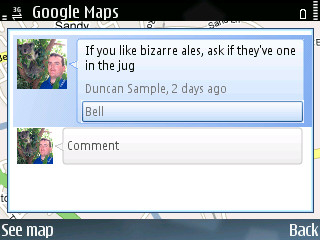
I very quickly realised that there wasn’t a new version of the GMail application, but there was a new version of Google Maps. This new version of Google Maps has integration with Google Buzz in the form of a Layer. Once turned on, this layer puts speech bubbles anywhere Buzz has been made. Add to this the fact that Buzz can be associated with places and businesses, this gives an excellent way to provide tips for people to find when they’re travelling.

I have to wonder, with Jyri Engeström having worked on features within Google Buzz, whether this is trying to, in any way build on the concept of the original Jaiku service (not the newer JaikuEngine-based service), where multiple feeds are taken into a single activity stream with location attached. One of my personal main use-cases of Jaiku was for travelling, so I could find people in the area to go for a drink with, and I have been lucky enough to get to know several people from around Finland because of it.

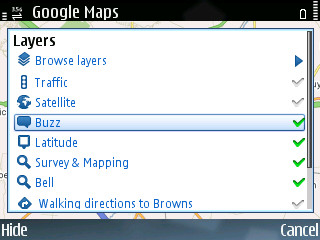
Enable the Buzz layer
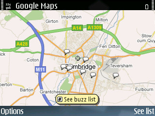
Buzz around Cambridge
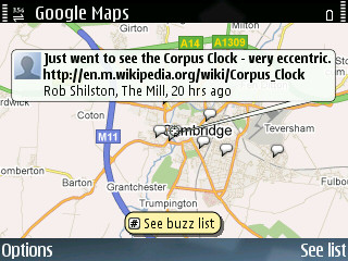
A location-specific Buzz

I’ve put some screenshots of how I used it on a night in the pub on Saturday.

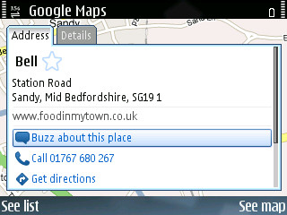
A pub on Google Maps
Buzz about the pub

Cost-effective GPS trackers

Having been on a road trip to Lapland in the summer and used a lot of different ways to track my location and share content (I know, I still need to write about it), Both Nicola and I are going to the Ice Hotel in Swedish Lapland for 4 days.

The main issue we had was keeping our mobiles logging our trip. They lost the satellites fairly often (and in the case of my N95 didn’t get much signal to begin with) and of course with GPS turned on constantly they didn’t really last that long on battery. So for this next trip I’ve decided to look at a dedicated device for location tracking.

After looking at Garmin and other devices I found two good possibilities which were around £50:

i-gotU (GT-120 & GT-200)
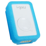
i-gotU

The site for this device is pretty, and they have some nice software for geotagging photos sending to Flickr/Picasa, although it’s Windows-only. Other than that, it’s pretty hard to find information about the devices, compare the differences in specifications and even to see how many points it can record or how long the battery lasts and how to recharge it.

The device looks really nice though and for the average user it would be a great, small tracker to fit in your pocket. Especially at £45.

GlobalSat DG-100
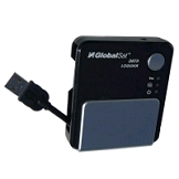
GlobalSat DG0-100

Not quite as pretty as the i-gotU, but has lots of details about the huge battery life (37 hours at 10 second interval captures) and more status indicators on the front of the device, as well as a hardware interval selector on the side.

Since the shops I looked at didn’t have any i-gotU in stock, and for the known brand of GlobalSat, I decided on the DG-100.

For this trip I’m planning on doing most of my photography using my Canon 350D SLR and Canon MD235 MiniDV camcorder, so there won’t be much live content apart some rare photos from my N95 and some Jaiku updates.

After the trip I’ll make sure to bookmark some time to posting what I used, as well as how they coped in the freezing temperatures.

Road-trip Location blogging

I’m going to Finland on Thursday to go on a road trip around Lapland and I’m planning to keep track of my location (and post something online automatically too). I’ll update this post soon with more information about how I do that. At the moment I’m thinking of using the following:

  • Nokia Sports Tracker – This should track my location as well as photos and videos taken along the way… A little more than a ‘sports’ tracker.
  • If I can get my GPS tracker up and running again I’ll use that too.
  • General GPS logger so that I can add the location metadata in post-production.

Create Position Art

Mona Lisa created in Position Art

Nokia’s newest viral marketing is based around the N82 and it’s integrated GPS. Stavros, an artist in Position Art, encourages you to make Position Art of your own by tracking your position using an application such as Nokia Sports Tracker, then share the work of art online.

The idea is fun, and if it gets people out and active then it can only be a good thing. As for the N82, having played briefly with one, it’s a solid device with superb build quality and a good GPS. I would even go as far as saying that it’s a good non-slider alternative to the N95. It may not have the 5MP camera of the N95 (only 3MP) but with a xenon flash the indoor picture quality is higher.

For more information about Stavros and his Position Art initiative visit The World Is My Canvas, and for a look at the viral ad that started it all at the Mobile Web Congress conference go to Stavros’ post on Share on Ovi

Google Maps gets a native S60v3 version

If you tried the previous Google Mobile Maps application before and have an S60v3 phone, you might want to update to the new native version. It’s got a smoother display and now supports GPS, so all you N95 (or bluetooth GPS) owners can see where you are.

It doesn’t do satnav yet, but it can’t be too long before Google comes up with something to rival the subscription-only navigation of Nokia Maps and Tomtom. The only benefit Nokia Maps currently has (on top of navigation) is that you can download the maps and store them on your phone.

If you’ve got a mobile barcode reader (and if you haven’t, why not get one?), you can use the barcode below to go straight to Google’s download page.

Google Mobile Maps

The iPhone as a GPS/SatNav

You may have seen the latest Steve Jobs WWDC Keynote and iPhone adverts and be wondering about how good it will perform as a GPS device (as you would any modern mobile phone) or for Location Based Services (LBS).

A lot of people are looking forward to the release of the iPhone, and I guess only time will tell as to how it performs, but I can see some things which may backfire with the fully online (or at least that’s what it seems) platform.

  • Steve hasn’t mentioned anything about GPS support within the iPhone, but I don’t see it not having support.
  • Unless there are some sophisticated caching mechanisms, maps are going to be unavailable in areas of low mobile network coverage.
  • Points of Interest appear built into the phone are most probably the normal Google Maps, and possibly not very customisable.
  • Other POIs are capable through the web browser, with AJAX these websites can appear as if they are native applications on the phone, but only through clicking on an address/location of some sort to trigger the Google Maps view of that point.

I hope to be proven wrong, but those are my reservations. If I am proven correct, this would surely be a major issue for anyone (like myself) who uses GPS/GIS in anger. Any ideas?

Lifecasting: Location Tracking

You may have seen Justin.tv or some other ‘live’ blogs (kind of like online reality television). Although I don’t think I could even remotely consider going that far, I do like the idea of allowing at least my friends and family to know where I am/what I’m doing. This post will concentrate on the ‘where I am’ part, I have posted some information relating to the ‘what I’m doing’ part on my other, more technical blog though, in case you’re interested.

So, you’ve got a GPS (eg. Nokia N95, or a Bluetooth GPS), you’re planning to keep it in your pocket all day and send location updates to the internet in some way, of course you’ll be utilising your mobile phone for this. There are two things to consider at this point… what are the requirements for the mobile phone software and what are the requirements for getting your location to somewhere useful (namely, the Internet).

I’ll discuss these two things separately.

Mobile Phone

For the mobile phone software (and I’ll be talking about Symbian S60 3.x based phones), we’re going to be looking for either a Java MIDP or Symbian S60 based application. The advantage of using a Java application is that it may also work on other varieties of phone. The downside is that they may not integrate as nicely into the phone’s features than S60 specific applications (such as the Location API) and may be a little harder on battery life (I haven’t confirmed this though).

Since we’re going to want to use our phone at the same time as sending location updates, the next requirements on the mobile side would be that the software not be too power hungry and that the software sit quietly in the background when asked. We don’t want anything being downloaded, such as maps, since this will also mean higher data usage and power consumption.

Note: Running a constant bluetooth and data connection will dramatically reduce battery life. The usual disclaimer about bandwidth prices on your operator apply.

So, who are the contenders for the mobile phone side?

Although Jaiku is good and puts your location online, it isn’t based on GPS (at least not at this time), instead it uses mobile phone cell information, so it’s not really usable for our little project.

3D Tracker works and has the simplistic features we want in terms of just the basic GPS tracking, but as far as I can see, it only sends up to a particular site which is not very nice to use (it’s seems a bit of an after-thought to their commercial site).

GMap-Track works, but it is constantly downloading map data and is also fixed to only send to their website, which at the moment is unfinished.

CoPilot Live 6 looks like they would do the job, but CoPilot looks far too heavy for our needs (it’s a full GPS routing system).

That leaves Aspicore GSM Tracker and AFTrack. I didn’t look closely enough at the Aspicore software and thought it hooked into some proprietary server software, but it appears to be possibly more flexible and open than AFTrack, which I purchased not so long ago. I may purchase the Aspicore software too as that does look better than AFTrack.

Both AFTrack and Aspicore GSM Tracker will do what we’re looking for, and I would now suggest using Aspicore over AFTrack, but I purchased AFTrack before reading into the Aspicore solution properly, so I will be using that for my system… Both applications work on the same principal though, so implementation should be almost identical.

The Web Service

Now we’ve chosen the mobile phone software we’re going to use, we can look at the Internet side of our solution. This is going to be a web service that takes the location information as input and allows you to display it in various different ways.

After a quick search there are many different services online that work with both AFTrack and Aspicore GSM Tracker.  There are also some services listed on the applications’ websites.  Each of the services I looked at, apart from GpsGate, had some major issues… they were either unfinished, unstable or 30 day trials/commercial sites.  What I was looking for was a (preferably free) service that had a somewhat nice feel to it.  We are, after all, going to be sending people to it.

GpsGate looks nice and seems to work fine, so you may find that suits your needs (Aspicore GSM Tracker is recommended for this site), but I wanted to be adventurous.

Since I wasn’t totally satisfied with the sites I looked at, I decided that I would develop my own service that works the way I want.  The service I have created can be found here.  It is under development, but I hope that over time, with enough feedback, I can make the site useful and feature-rich.

I have made the service free for single devices (I may have to charge a small amount for business use) and currently displays your location, with some history, on a Google Map and also allows you to have your location streaming near-live using Google Earth (it updates every minute).  I will describe below about how I’ve developed it, but I would appreciate as much feedback as possible about the service so I can develop the features you want to use.

Being More Adventurous

If you’re not scared by programming and you have some patience you might want to investigate creating your own tracking site as I have done.  I used nothing other than Ruby on Rails and the Google Maps API to create my service, but if you want some code to start from I suggest looking at Aspicore’s PHP Tools page.

I will describe in future posts how I made different parts of the service.

Overall I’m happy with the outcome of the system.  The final result was better than I expected for a first attempt, but I can already see some future improvements:

  • I like Free and Open Source Software, so I would like to develop an Open Source GPS tracker client as a community project.  This would allow the service I have created to be truly free for individuals, and so should get a lot more users.
  • I am trying to devise a way that the location information collected using the service could be turned into a ‘badge’ (small image/’widget’) that could be placed on a user’s blog.

Beyond…

Doing this project got me thinking… What else could we use the information we’re gathering about ourselves for?  The simple answer I came up with was… anything!  Currently I use ShoZu (another mobile application) to ‘tag’ photos I take with my location before sending them to Flickr.  I have also integrated GeoRSS into this blog.  What is stopping these (and others) being integrated with the information we already have apart from an open API?  I’ll discuss this in a future post.